Comments

14 comments

  • qiu

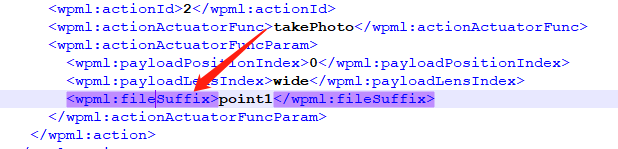
    waylines文件里面加上api文档里所写的 添加拍摄照片名称后缀 的标签  为何执行航线文件后拍摄的照片还是默认文件名?

    0
    Comment actions Permalink
  • Boerma

    SD卡里看到后缀名没有添加上?

    0
    Comment actions Permalink
  • qiu

    是的  sd卡里也是默认名

    0
    Comment actions Permalink
  • Boerma

    你啥飞机和载荷啊,pilot 2上试过吗?

    0
    Comment actions Permalink
  • qiu

    RTK 300  负载L1 就是用pilot 2 飞的航线文件   

    0
    Comment actions Permalink
  • Boerma

    你提单子吧,可能是bug

    0
    Comment actions Permalink
  • qiu

    那还有什么办法能把拍摄点位信息关联到图片上吗。。我看到有经纬度但是精度达不到   KML文件标记好的点位信息转KMZ就丢失了  想通过加后缀到文件名还有bug 太难了

    0
    Comment actions Permalink
  • Boerma

    图片的exif,xmpp信息里就有经纬度、云台姿态等信息

    0
    Comment actions Permalink
  • qiu

    有是有  但不还得拿解析出来的经纬度再去跟kml解析出来的测点做对应 才能确定这个拍摄点部位嘛...

    0
    Comment actions Permalink
  • Boerma

    一样的吧,对于程序而言,读文件名称和读gps信息,没什么区别,速度是一样的,就是代码不一样😂

    0
    Comment actions Permalink
  • qiu

    行 哥 谢谢哈  我在看看

    0
    Comment actions Permalink
  • DJI Developer Support
    有一种可能是kmz编辑有问题,我建议你在DJI Pilot 2上生成一份KMZ,再和你自己写得这个做对比。DJI Pilot 2运行地是template.kml文件,MSDK运行地是waylines.wpml文件。光看你这点代码没啥问题。
    0
    Comment actions Permalink
  • qiu

    那么机场运行的也是template.kml吗 我看上云API里都是对waylines.wpml的校验

    0
    Comment actions Permalink
  • DJI Developer Support
    机场运行的是waylines文件
    0
    Comment actions Permalink

Please sign in to leave a comment.